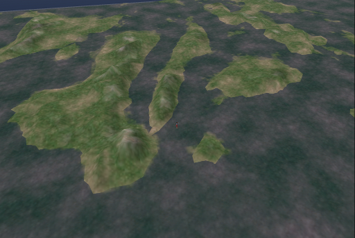
I had to drop this from my project as it involve 64 sims. GIS data was used to create the terrain. I'm going to post the documentation on how I did it later. This proves that OpenSim is not just a toy, it can be used for teaching GIS, geography and geology at a distance.
Hard Surface Sculpting Course Free Lesson
-
Jan van den Hemel writes: In this free lesson from my Hard Surface
Sculpting course, we look at how to make tiling displacement maps, a tool
that allows fo...
A Conversation with ChatGPT about Vox114
-
*Me:* *If you are given a robot body and would be able to explore the
physical world, where would you go first and what would you do? *
*ChatGPT:* If I w...
Streamlining our behind-the-scenes administration
-
There’s a lot that goes on behind the scenes of maintaining any software
project that may not be obvious to end-users. This includes providing and
managing...
Call For Content: Blenderart Magazine issue #48
-
We are ready to start gathering up tutorials, making of articles and images
for Issue # 48 of Blenderart Magazine. The theme for this issue is “Time
Flies:...
Baybayin keyboard layout para sa Linux
-
Sa wakas may gumawa ng ng keyboard layout ng baybayin para sa Linux.
Nilikha ito ng *Ubuntu Philippines LoCo Team* project at nasa kanilang *Philippines
“...


No comments:
Post a Comment